
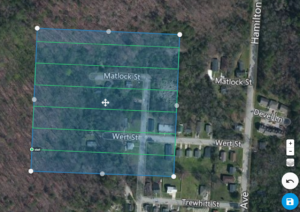
Drone Aerial Mapping Land surveyors have always produced drawings that show the…
This is the Daily Digest from Land Surveyors United Community. Share your Surveying Life with us!
@landsurveyorsu • September 30, 2024, 12:32 am
LAND SURVEYORS UNITED ✊ ɢʟᴏʙᴀʟ sᴜʀᴠᴇʏɪɴɢ ᴄᴏᴍᴍᴜɴɪᴛʏ @LandSurveyorsU
Drone Aerial Mapping Land surveyors have always produced drawings that show the property as if you were looking at it from above the…
@landsurveyorsu • October 5, 2024, 12:20 am
LAND SURVEYORS UNITED ✊ ɢʟᴏʙᴀʟ sᴜʀᴠᴇʏɪɴɢ ᴄᴏᴍᴍᴜɴɪᴛʏ @LandSurveyorsU
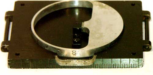
What is a Land Surveyor Compass? A Comprehensive History to Modern Times Compass surveying is a type of surveying in which the…

@landsurveyorsu • October 4, 2024, 7:49 pm
LAND SURVEYORS UNITED ✊ ɢʟᴏʙᴀʟ sᴜʀᴠᴇʏɪɴɢ ᴄᴏᴍᴍᴜɴɪᴛʏ @LandSurveyorsU
Common Mistakes to Avoid in Land Surveyor Calculations: A Guide for Professionals landsurveyorsunited.com/forum/topics/c…
@landsurveyorsu • October 3, 2024, 12:20 am
LAND SURVEYORS UNITED ✊ ɢʟᴏʙᴀʟ sᴜʀᴠᴇʏɪɴɢ ᴄᴏᴍᴍᴜɴɪᴛʏ @LandSurveyorsU
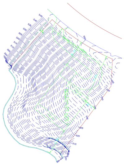
Topographic Survey What is the purpose of a Topographic Survey? Topographic surveys are usually carried out in order to have an…
Follow Us on Twitter @landsurveyorsU
Follow us on Facebook @landsurveyorsunited
Drone Aerial Mapping Land surveyors have always produced drawings that show the…
![Drone Aerial Mapping Land surveyors have always produced drawings that show the…]() Reviewed by Land Surveyors United
on
10/07/2024 08:03:00 PM
Rating:
Reviewed by Land Surveyors United
on
10/07/2024 08:03:00 PM
Rating:


No comments