
Drone Aerial Mapping Land surveyors have always produced drawings that show the…
This is the Daily Digest from Land Surveyors United Community. Share your Surveying Life with us!

@landsurveyorsu • October 14, 2024, 12:29 pm
LAND SURVEYORS UNITED ✊ ɢʟᴏʙᴀʟ sᴜʀᴠᴇʏɪɴɢ ᴄᴏᴍᴍᴜɴɪᴛʏ @LandSurveyorsU
Drone Aerial Mapping Land surveyors have always produced drawings that show the property as if you were looking at it from above the…
@landsurveyorsu • October 13, 2024, 12:20 pm
LAND SURVEYORS UNITED ✊ ɢʟᴏʙᴀʟ sᴜʀᴠᴇʏɪɴɢ ᴄᴏᴍᴍᴜɴɪᴛʏ @LandSurveyorsU
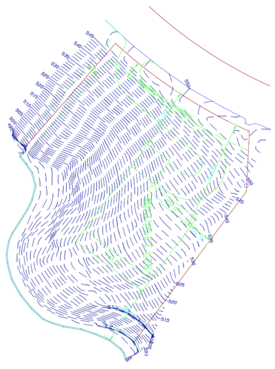
Topographic Survey What is the purpose of a Topographic Survey? Topographic surveys are usually carried out in order to have an…

@landsurveyorsu • October 12, 2024, 12:32 pm
LAND SURVEYORS UNITED ✊ ɢʟᴏʙᴀʟ sᴜʀᴠᴇʏɪɴɢ ᴄᴏᴍᴍᴜɴɪᴛʏ @LandSurveyorsU
Fundamentals of Surveying (Playlist 17 Video Tutorials) 1 27:05 Now playing Lecture 1: Distance Measurement CKV • 11K…

@landsurveyorsu • October 10, 2024, 12:35 pm
LAND SURVEYORS UNITED ✊ ɢʟᴏʙᴀʟ sᴜʀᴠᴇʏɪɴɢ ᴄᴏᴍᴍᴜɴɪᴛʏ @LandSurveyorsU
Now You Can Post to Any Local Surveyor Chapter from an Interactive Map Today we are introducing the first part of a massive…

@landsurveyorsu • October 6, 2024, 12:26 pm
LAND SURVEYORS UNITED ✊ ɢʟᴏʙᴀʟ sᴜʀᴠᴇʏɪɴɢ ᴄᴏᴍᴍᴜɴɪᴛʏ @LandSurveyorsU
Fundamentals of Surveying (Playlist 17 Video Tutorials) 1 27:05 Now playing Lecture 1: Distance Measurement CKV • 11K…
Follow Us on Twitter @landsurveyorsU
Follow us on Facebook @landsurveyorsunited
Drone Aerial Mapping Land surveyors have always produced drawings that show the…
![Drone Aerial Mapping Land surveyors have always produced drawings that show the…]() Reviewed by Land Surveyors United
on
10/15/2024 08:01:00 PM
Rating:
Reviewed by Land Surveyors United
on
10/15/2024 08:01:00 PM
Rating:


No comments