
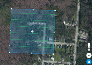
Drone Aerial Mapping Land surveyors have always produced drawings that show the…
This is the Daily Digest from Land Surveyors United Community. Share your Surveying Life with us!
@landsurveyorsu • November 14, 2024, 12:26 pm
LAND SURVEYORS UNITED ✊ ɢʟᴏʙᴀʟ sᴜʀᴠᴇʏɪɴɢ ᴄᴏᴍᴍᴜɴɪᴛʏ @LandSurveyorsU
Drone Aerial Mapping Land surveyors have always produced drawings that show the property as if you were looking at it from above the…

@landsurveyorsu • November 9, 2024, 12:29 pm
LAND SURVEYORS UNITED ✊ ɢʟᴏʙᴀʟ sᴜʀᴠᴇʏɪɴɢ ᴄᴏᴍᴍᴜɴɪᴛʏ @LandSurveyorsU
Fundamentals of Surveying (Playlist 17 Video Tutorials) 1 27:05 Now playing Lecture 1: Distance Measurement CKV • 11K…
@landsurveyorsu • November 7, 2024, 12:08 am
LAND SURVEYORS UNITED ✊ ɢʟᴏʙᴀʟ sᴜʀᴠᴇʏɪɴɢ ᴄᴏᴍᴍᴜɴɪᴛʏ @LandSurveyorsU
What is a Land Surveyor Compass? A Comprehensive History to Modern Times Compass surveying is a type of surveying in which the…

@landsurveyorsu • November 8, 2024, 12:14 pm
LAND SURVEYORS UNITED ✊ ɢʟᴏʙᴀʟ sᴜʀᴠᴇʏɪɴɢ ᴄᴏᴍᴍᴜɴɪᴛʏ @LandSurveyorsU
Drone Aerial Mapping Land surveyors have always produced drawings that show the property as if you were looking at it from above the…
Follow Us on Twitter @landsurveyorsU
Follow us on Facebook @landsurveyorsunited
Drone Aerial Mapping Land surveyors have always produced drawings that show the…
![Drone Aerial Mapping Land surveyors have always produced drawings that show the…]() Reviewed by Land Surveyors United
on
11/18/2024 06:42:00 PM
Rating:
Reviewed by Land Surveyors United
on
11/18/2024 06:42:00 PM
Rating:


No comments