
Drone Aerial Mapping Land surveyors have always produced drawings that show the…
This is the Daily Digest from Land Surveyors United Community. Share your Surveying Life with us!

@landsurveyorsu • October 4, 2024, 12:11 pm
LAND SURVEYORS UNITED ✊ ɢʟᴏʙᴀʟ sᴜʀᴠᴇʏɪɴɢ ᴄᴏᴍᴍᴜɴɪᴛʏ @LandSurveyorsU
Drone Aerial Mapping Land surveyors have always produced drawings that show the property as if you were looking at it from above the…

@landsurveyorsu • October 3, 2024, 12:20 am
LAND SURVEYORS UNITED ✊ ɢʟᴏʙᴀʟ sᴜʀᴠᴇʏɪɴɢ ᴄᴏᴍᴍᴜɴɪᴛʏ @LandSurveyorsU
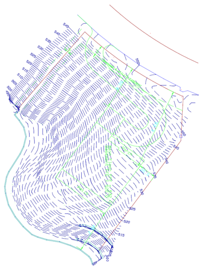
Topographic Survey What is the purpose of a Topographic Survey? Topographic surveys are usually carried out in order to have an…
@landsurveyorsu • October 1, 2024, 12:23 pm
LAND SURVEYORS UNITED ✊ ɢʟᴏʙᴀʟ sᴜʀᴠᴇʏɪɴɢ ᴄᴏᴍᴍᴜɴɪᴛʏ @LandSurveyorsU
Topographic Survey What is the purpose of a Topographic Survey? Topographic surveys are usually carried out in order to have an…

@landsurveyorsu • September 27, 2024, 12:23 pm
LAND SURVEYORS UNITED ✊ ɢʟᴏʙᴀʟ sᴜʀᴠᴇʏɪɴɢ ᴄᴏᴍᴍᴜɴɪᴛʏ @LandSurveyorsU
Now You Can Post to Any Local Surveyor Chapter from an Interactive Map Today we are introducing the first part of a massive…
@landsurveyorsu • September 27, 2024, 12:14 am
LAND SURVEYORS UNITED ✊ ɢʟᴏʙᴀʟ sᴜʀᴠᴇʏɪɴɢ ᴄᴏᴍᴍᴜɴɪᴛʏ @LandSurveyorsU
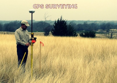
Land Surveyor GPS Professional measurement and Land surveying has been in use for centuries and is widely known as the second oldest…
Follow Us on Twitter @landsurveyorsU
Follow us on Facebook @landsurveyorsunited
Drone Aerial Mapping Land surveyors have always produced drawings that show the…
![Drone Aerial Mapping Land surveyors have always produced drawings that show the…]() Reviewed by Land Surveyors United
on
10/04/2024 07:54:00 PM
Rating:
Reviewed by Land Surveyors United
on
10/04/2024 07:54:00 PM
Rating:


No comments