
Drone Aerial Mapping Land surveyors have always produced drawings that show the…
This is the Daily Digest from Land Surveyors United Community. Share your Surveying Life with us!

@landsurveyorsu • February 9, 2023, 12:07 am
Lᴀɴᴅ Sᴜʀᴠᴇʏᴏʀs Uɴɪᴛᴇᴅ ✊ Gʟᴏʙᴀʟ Sᴜʀᴠᴇʏɪɴɢ Cᴏᴍᴍᴜɴɪᴛʏ @LandSurveyorsU
Drone Aerial Mapping Land surveyors have always produced drawings that show the property as if you were looking at it from above the…

@landsurveyorsu • February 8, 2023, 3:53 pm
Lᴀɴᴅ Sᴜʀᴠᴇʏᴏʀs Uɴɪᴛᴇᴅ ✊ Gʟᴏʙᴀʟ Sᴜʀᴠᴇʏɪɴɢ Cᴏᴍᴍᴜɴɪᴛʏ @LandSurveyorsU
Basic Topographic Survey| Land Survey|Azimuth With Sokkia Total Station, @ Aims surveying Training. -…
@landsurveyorsu • February 6, 2023, 3:09 pm
Lᴀɴᴅ Sᴜʀᴠᴇʏᴏʀs Uɴɪᴛᴇᴅ ✊ Gʟᴏʙᴀʟ Sᴜʀᴠᴇʏɪɴɢ Cᴏᴍᴍᴜɴɪᴛʏ @LandSurveyorsU
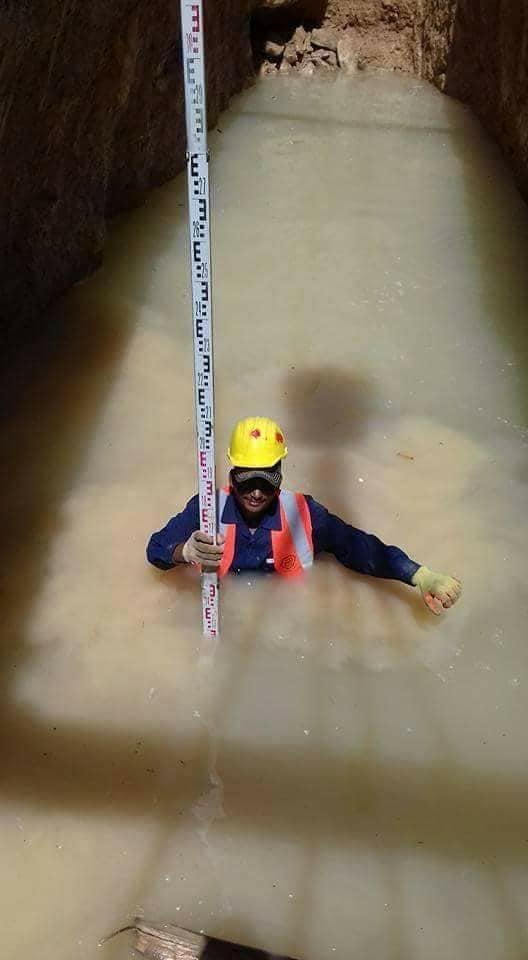
Who else has been in this position?
In #surveying, sometimes you just have to get wet... https://t.co/jyJ1qTGnIQ

@landsurveyorsu • February 5, 2023, 6:54 pm
Lᴀɴᴅ Sᴜʀᴠᴇʏᴏʀs Uɴɪᴛᴇᴅ ✊ Gʟᴏʙᴀʟ Sᴜʀᴠᴇʏɪɴɢ Cᴏᴍᴍᴜɴɪᴛʏ @LandSurveyorsU
Non- Robotic
Share you favorite photos of Non-Robotic Total Stations at work! https://t.co/5oFTVX3odA
Follow Us on Twitter @landsurveyorsU
Follow us on Facebook @landsurveyorsunited
Drone Aerial Mapping Land surveyors have always produced drawings that show the…
![Drone Aerial Mapping Land surveyors have always produced drawings that show the…]() Reviewed by Land Surveyors United
on
2/11/2023 06:54:00 PM
Rating:
Reviewed by Land Surveyors United
on
2/11/2023 06:54:00 PM
Rating:


No comments