This is the Daily Digest from Land Surveyors United Community. Share your Surveying Life with us!

@landsurveyorsu • September 4, 2025, 12:34 pm
LAND SURVEYORS UNITED ✊ ɢʟᴏʙᴀʟ sᴜʀᴠᴇʏɪɴɢ ᴄᴏᴍᴍᴜɴɪᴛʏ @LandSurveyorsU
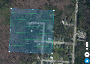
Drone Aerial Mapping Land surveyors have always produced drawings that show the property as if you were looking at it from above the…
@landsurveyorsu • September 3, 2025, 12:27 am
LAND SURVEYORS UNITED ✊ ɢʟᴏʙᴀʟ sᴜʀᴠᴇʏɪɴɢ ᴄᴏᴍᴍᴜɴɪᴛʏ @LandSurveyorsU
Drone Aerial Mapping Land surveyors have always produced drawings that show the property as if you were looking at it from above the…

@landsurveyorsu • August 26, 2025, 12:31 am
LAND SURVEYORS UNITED ✊ ɢʟᴏʙᴀʟ sᴜʀᴠᴇʏɪɴɢ ᴄᴏᴍᴍᴜɴɪᴛʏ @LandSurveyorsU
Drone Aerial Mapping Land surveyors have always produced drawings that show the property as if you were looking at it from above the…

@landsurveyorsu • August 28, 2025, 12:15 am
LAND SURVEYORS UNITED ✊ ɢʟᴏʙᴀʟ sᴜʀᴠᴇʏɪɴɢ ᴄᴏᴍᴍᴜɴɪᴛʏ @LandSurveyorsU
What is a Land Surveyor Compass? A Comprehensive History to Modern Times Compass surveying is a type of surveying in which the…

@landsurveyorsu • August 27, 2025, 12:37 am
LAND SURVEYORS UNITED ✊ ɢʟᴏʙᴀʟ sᴜʀᴠᴇʏɪɴɢ ᴄᴏᴍᴍᴜɴɪᴛʏ @LandSurveyorsU
Drone Aerial Mapping Land surveyors have always produced drawings that show the property as if you were looking at it from above the…
Follow Us on Twitter @landsurveyorsU
Follow us on Facebook @landsurveyorsunited