
This is the Daily Digest from Land Surveyors United Community. Share your Surveying Life with us!

@landsurveyorsu • April 10, 2025, 9:28 pm
LAND SURVEYORS UNITED ✊ ɢʟᴏʙᴀʟ sᴜʀᴠᴇʏɪɴɢ ᴄᴏᴍᴍᴜɴɪᴛʏ @LandSurveyorsU
Thank you for this Leica so that I may survey land. https://t.co/RA6IqAtMIb

@landsurveyorsu • April 10, 2025, 5:24 pm
LAND SURVEYORS UNITED ✊ ɢʟᴏʙᴀʟ sᴜʀᴠᴇʏɪɴɢ ᴄᴏᴍᴍᴜɴɪᴛʏ @LandSurveyorsU
RT @vintagemapstore: Bird's-eye view map of Japan (1921) https://t.co/TlsEfyVEpC
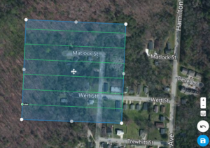
@landsurveyorsu • April 10, 2025, 12:17 am
LAND SURVEYORS UNITED ✊ ɢʟᴏʙᴀʟ sᴜʀᴠᴇʏɪɴɢ ᴄᴏᴍᴍᴜɴɪᴛʏ @LandSurveyorsU
Drone Aerial Mapping Land surveyors have always produced drawings that show the property as if you were looking at it from above the…
Follow Us on Twitter @landsurveyorsU
Follow us on Facebook @landsurveyorsunited
No comments:
Post a Comment