
Drone Aerial Mapping Land surveyors have always produced drawings that show the…
This is the Daily Digest from Land Surveyors United Community. Share your Surveying Life with us!

@landsurveyorsu • September 20, 2024, 12:32 pm
LAND SURVEYORS UNITED ✊ ɢʟᴏʙᴀʟ sᴜʀᴠᴇʏɪɴɢ ᴄᴏᴍᴍᴜɴɪᴛʏ @LandSurveyorsU
Drone Aerial Mapping Land surveyors have always produced drawings that show the property as if you were looking at it from above the…
@landsurveyorsu • September 16, 2024, 12:23 pm
LAND SURVEYORS UNITED ✊ ɢʟᴏʙᴀʟ sᴜʀᴠᴇʏɪɴɢ ᴄᴏᴍᴍᴜɴɪᴛʏ @LandSurveyorsU
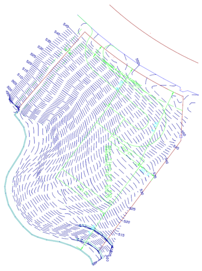
Topographic Survey What is the purpose of a Topographic Survey? Topographic surveys are usually carried out in order to have an…

@landsurveyorsu • September 12, 2024, 6:14 pm
LAND SURVEYORS UNITED ✊ ɢʟᴏʙᴀʟ sᴜʀᴠᴇʏɪɴɢ ᴄᴏᴍᴍᴜɴɪᴛʏ @LandSurveyorsU
Continuing Education Hub opens on Monday! Get a jump on the excitement by joining the hub here: …
Follow Us on Twitter @landsurveyorsU
Follow us on Facebook @landsurveyorsunited
Drone Aerial Mapping Land surveyors have always produced drawings that show the…
![Drone Aerial Mapping Land surveyors have always produced drawings that show the…]() Reviewed by Land Surveyors United
on
9/20/2024 07:57:00 PM
Rating:
Reviewed by Land Surveyors United
on
9/20/2024 07:57:00 PM
Rating:


No comments